From the pad to the constellation: PadWatch

Spaceflight gets reported as a departure. A rocket left this pad on this day, carrying that payload. Where it was actually going, the orbit it climbed to reach, stays an abstraction, even though the orbit is the entire point of the launch. We watch the part that looks dramatic and lose the part that matters.
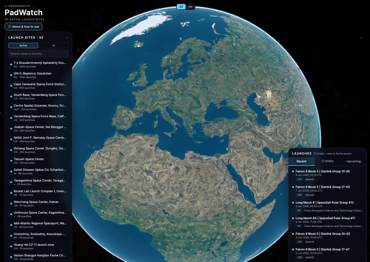
PadWatch exists to put that part back. It takes the orbit a launch reached, which is already sitting in open data, and shows it to you on a globe you can fly around. Pick a recent launch, and the camera drops to the pad it left from, then watches the vehicle climb off the ground and resolve into the exact orbital ring it is on today. One click takes you from a point on a map to a line around the planet.
That is the half of the story the trackers leave out. They tell you when a rocket goes up and where from, then stop at the edge of the atmosphere. The question worth answering is where it ended up, and PadWatch answers it by flying you there.
It is now live at padwatch.swarmwatch.dev and is the sister app to Swarmwatch. Swarmwatch shows what is alive in orbit right now (from a mainly LEO perspective). PadWatch shows how it got there. Run them together, and you can follow the whole arc, from a single pad in California to a shell of satellites passing overhead.
The click-to-orbit moment
The map itself is the easy part. There are 51 publicly known orbital launch sites mapped worldwide, and plenty of trackers will plot those for you and list what is going up next week.
The part I cared about is what happens after the click. Select a catalogued launch, and the camera flies down to the pad, then watches the vehicle climb from the ground and join its orbit. The ascent reads as a clean trajectory off the surface that hands over, without a join you can see, to the ring the object is on today. The aim was to turn an abstract sentence, "Starlink launched from Vandenberg," into something you can actually watch and send to someone.
It also makes the geography of spaceflight legible in a way a list of coordinates never will. You can see why launches headed for polar orbits go from particular sites, and why the Cape leans east out over the Atlantic. The launch azimuth on each ascent is derived from the site latitude and the target inclination, so the direction a rocket leaves is doing real work on screen rather than being decorative.
Built entirely on open data
There is nothing proprietary feeding this. The launch-site gazetteer comes from Jonathan McDowell's GCAT. The live launch schedule comes from The Space Devs' Launch Library 2. The orbits come from CelesTrak's element sets and satellite catalogue. Anyone can inspect every one of those feeds.
A Cesium 3D globe does the rendering. The orbit is propagated in the browser with satellite.js, straight from the real two-line element set, so the ring sits exactly where the object went rather than somewhere approximate. Recent launches show their real orbits as soon as they are catalogued, and the rest appear within a few days once an element set exists for them.
The whole thing runs self-hosted on a small Proxmox container and refreshes its data overnight. It did not need a cloud bill or a data partnership, and that felt like part of the point.
What is real, and what is modelled
The orbit is real. It is propagated from the published element set, and you can verify it against the catalogue yourself. The ascent is modelled. No public ascent telemetry exists for most flights, so the climb you watch is a physically reasonable path built to meet the real orbit cleanly, not a recording of the actual trajectory.
PadWatch says so on the screen. The orbit is verifiable and labelled as such, and the ascent is labelled as modelled. A visualisation that blurs the two, teaches people something false, and there is no reason to do that when the honest and data true version is more interesting anyway.
Why I built it
Existing tools answer "when" and "from where," leaving the most interesting question on the table: "and to where." That answer is already in open data. It just needed joining up and putting on a globe you can fly around.
The broader thread is the same as the one behind Swarmwatch. The orbital environment is getting busier and harder to picture, and much of the public conversation runs on intuition rather than what is observable. Anything that makes the real picture easier to see, on data anyone can check, is worth building.
Have a look at padwatch.swarmwatch.dev, pick a recent launch, and watch it climb. If you want to see where everything ends up afterwards, Swarmwatch is waiting at the other end of the arc.